
With clouds that covered nearly the entire country, Uwan (Fung Wong) is the Philippines’ biggest storm going by sheer size this year, peaking at a diameter of over 1,800 kilometers.
The Philippine Atmospheric, Geophysical, and Astronomical Services Administration (PAGASA) said this length is equivalent to the entire stretch from Batanes to Jolo, which also means its effects were felt across all three of the country’s major island groups of Luzon, Visayas, and Mindanao.
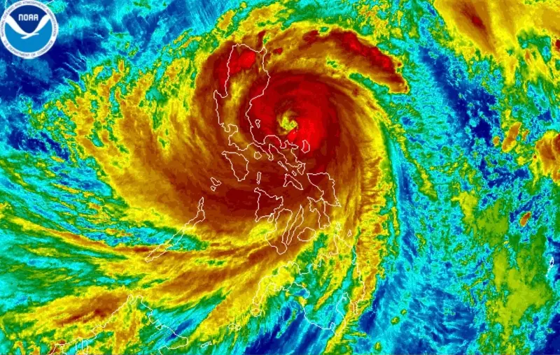
At its most intense, Uwan was classified as a super typhoon at 185 kilometers per hour, but it was not the country’s most destructive or deadliest this year; those titles belong to Super Typhoon Nando (Ragasa) and Typhoon Tino, respectively.
So, how did Uwan become so big, and why did it weaken into a typhoon as it traveled across the country? Here’s what you need to know.
How did Uwan form?
According to PAGASA, tropical cyclones form if four necessary requirements are met. (READ: EXPLAINER: How tropical cyclones form)
First, it must form over a large ocean area with a surface temperature of 26 degrees Celsius or 27°C.
Second, it is detected within 5° of latitude (about 555 kilometers) from the equator, although it will only intensify into a typhoon when it is more than 5° of latitude from the equator.
Third, there must be a weak vertical wind shear, which means there should be little change in wind speed and direction with altitude.
Fourth, there should already be a weak weather disturbance in an area that meets the previous requirements.
In the case of Uwan, it began as a low pressure area somewhere in the western North Pacific Ocean near Guam, according to the Joint Typhoon Warning Center’s November 3 advisory.
Favorable conditions in this vicinity allowed this weather disturbance to intensify rapidly: sea surface temperatures were warm enough at 29-30°C, the vertical wind shear was weak at 5-10 knots, and moderate airflow blew toward the equator.
According to PAGASA, Uwan moved slowly as it formed, giving it time to gather strength as it traveled the ocean. It also moved along the southern edge of a subtropical high, which refers to an area 30 degrees north and south of the equator, allowing it to intensify further, according to the Japan Meteorological Agency.
As a result, this weather disturbance strengthened into a tropical depression on November 4, a tropical storm and severe tropical storm on November 6, a typhoon on November 7, and a super typhoon on November 9.
Why is Uwan so large?
Studies from Harvard University and the American Meteorological Society (AMA) say that factors affecting the size of a tropical cyclone are not yet fully understood. However, theories from both of these studies are related to heat and humidity.
In 2015, a Harvard study found that an increase in sea surface temperature, a temperature decrease in the upper troposphere, and a large or strong initial vortex can lead to the tropical cyclones growing larger in diameter.
The AMA’s 2009 study pointed to environmental humidity, or the amount of water vapor in the air, since the intensity and coverage of precipitation outside a tropical cyclone’s core is strongly sensitive to these conditions.
Another 2018 study from the AMA also found that many tropical cyclones that traverse the Philippines have been increasing in size rather than decreasing because of the “strong southwesterly wind in the south of the South China Sea that raised relative humidity, warmed the sea surface, and increased import of angular momentum flux.”
The ocean already hit its warmest year on record in 2024, but preliminary data in 2025 show that ocean heat has continued to rise, according to the World Meteorological Organization (WMO).
“Ocean warming rates show a particularly strong increase over the past two decades, in an indication of how rapidly the Earth system is trapping surplus energy in the form of heat,” the WMO explained. “Over 90% of that energy goes into warming the ocean.”
WMO Secretary-General Celeste Saulo blamed this on heat-trapping greenhouse gases, which she said reached their highest levels within the past 800,000 years.
How does Uwan compare to other tropical cyclones?
Uwan may have been the largest storm to hit the country so far in 2025, but it is not the strongest or the most intense.
“Size is not necessarily an indication of hurricane intensity,” explained the National Oceanic and Atmospheric Administration (NOAA).
In the case of the Philippines, the most intense to hit the country this year is Super Typhoon Nando (Ragasa) at 215 kilometers per hour compared to Uwan’s 185 km/h.
Larger tropical cyclones have also hit the Philippines in previous years. On record, Super Typhoon Warling (Tip), which hit in 1979, is the world’s largest and most intense storm at a diameter of 2,200 km and a sustained wind speed of 306 km/h.
For reference, NOAA said tropical cyclones are typically about 300 miles (483 km) wide, although they can vary considerably.
Though smaller than Warling and Uwan, other large tropical cyclones have also hit the Philippines in the past.
Super Typhoon Yolanda, the Philippines’ deadliest typhoon in recent history, had a diameter of about 800 km. Other large tropical cyclones that hit the Philippines in the past include Typhoon Kiko (Morakot) in 2021 and Super Typhoon Odette (Usagi) in 2013 at diameters of 1,200 km and 1,110 km, respectively. (READ: Yolanda and the world’s strongest storms)
Why did it weaken?
Uwan weakened from a peak intensity of 185 km/h to 165 km/h, downgrading into a typhoon as it crossed Northern Luzon early Monday, November 10, following its landfall in Aurora.
On social media, satellite images showing the storm’s eye “disappearing” after crossing Luzon went viral. Users often attributed it to the Sierra Madre mountain range.
The Department of Science and Technology clarified that while the Sierra Madre can help weaken a storm’s winds, it only does so by 1-13%. The Cordillera Mountain Range has a larger effect on weakening wind speeds at 8-30%, based on a 2023 study by Gerry Bagtasa and Bernard Alan Racoma.
The same study added that the Sierra Madre only acts as a barrier for both wind and rain in Cagayan Valley. The mountain range instead enhances rainfall for the rest of Luzon by 23-55%.
According to PAGASA, tropical cyclones naturally weaken as they move inland, but not before they have already caused great destruction. – Rappler.com