Super Typhoon Uwan resulted in storm surge, lahar flow, and flooding in parts of the Bicol Region on Sunday morning, according to the Office of Civil Defense (OCD).
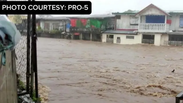
“Incidents reported so far sa Bicol as of 10 o'clock, meron na pong reported flooding in Barangay Masarawag in Guinobatan, Albay. Ito ang palaging problema kapag may lahar flow,” OCD deputy administrator for administration Assistant Secretary Bernardo Rafaelito Alejandro IV said during a press conference.
(Incidents reported so far in Bicol as of 10 o'clock, there is already a reported flooding in Barangay Masarawag in Guinobatan, Albay. This is always a problem when there is a lahar flow.)
“Sa Virac, Catanduanes naman, yun nga may mga reported storm surge and reported floodings also in Virac—Barangay Gogon, San Isidro, Imelda Boulevard—and reported floodings in Gigmoto, Catanduanes,” he added.
(In Virac, Catanduanes, there were reported storm surges and flooding also in Virac—Barangay Gogon, San Isidro, Imelda Boulevard—and reported flooding in Gigmoto, Catanduanes.)
Power outages and a lack of water supply were reported in Bicol. Communication line issues persisted in Bato and Pandan towns in Catanduanes.
As of 11 a.m., Alejandro said 916,863 individuals or 270,682 families have been preemptively evacuated from their homes.
Evacuations took place in Cordillera Administrative Region, Ilocos Region, Cagayan Valley, Central Luzon, Calabarzon, Mimaropa, Metro Manila, Bicol, Western Visayas, Central Visayas, and Eastern Visayas.
Most of the evacuees were reported in Bicol with 660,721 individuals, followed by Eastern Visayas with 112,760 and Calabarzon with 74,388 people.
In an 11 a.m. bulletin, state weather bureau PAGASA said Uwan was spotted over the coastal waters of Pandan, Catanduanes.
The super typhoon was packing maximum sustained winds of 185 kilometers per hour (kph) near the center and gusts of up to 230 kph.
Uwan was moving west northwestward at 30 kph.
The super typhoon will continue to move over the coastal waters of Catanduanes, pass close to Calaguas and Polillo Islands Sunday morning and afternoon, respectively.
Uwan will then make landfall at or near its peak intensity over the central portion of Aurora on Sunday evening or early Monday morning.
“Due to its proximity, a direct hit (i.e., eyewall affecting the area without making landfall) over Calaguas and Polillo Islands is possible,” PAGASA said. —RF, GMA Integrated News