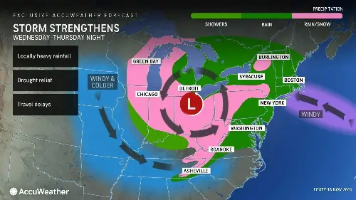
A significant storm is brewing over the Great Lakes region this week, bringing the potential for the season's first accumulating snowfall in parts of the Northeast, along with gusty winds and much-needed rain in drought-stricken areas.
The storm will affect a wide swath of the region, delivering diverse weather impacts, according to AccuWeather chief on-air meteorologist Bernie Rayno.
"This beneficial rain will help with the smoldering brush fires and drought conditions across the northeast. The storm will then move across Ohio and Pennsylvania," he said in a media advisory on Monday.
He added that the storm will also bring snow to higher elevations, including the Laurel Highlands of Pennsylvania and along the Appalachian range, stretching as far south as North Carolina.
As cold air surges into the region and moves over the warmer waters of the Great Lakes, lake-effect snow will likely develop, potentially becoming heavy in some areas.
Snowfall is also forecast for parts of the Ohio Valley and the central and southern Appalachians, beginning Wednesday night and persisting through the weekend.
Meteorologists are predicting 3 to 6 inches of snow in higher elevations of southwestern Pennsylvania, Maryland and West Virginia, with localized maximums of up to 24 inches.
Winds will intensify starting Wednesday and peak Thursday into Friday, with some areas experiencing sustained gusts into the weekend.
These winds are expected to churn up rough waves on the Great Lakes and could lead to renewed power outages in parts of the southern Appalachians, still recovering from damage caused by Hurricane Helene in late September.
The storm is expected to bring showers and possibly thunderstorms to parts of the Eastern U.S., though meteorologists caution that the rainfall may not be sufficient to substantially improve drought conditions in some areas.
The Northeast has seen worsening drought, with 96 percent of the region now classified as abnormally dry or experiencing drought conditions, according to AccuWeather.
The U.S. Drought Monitor reported that northern West Virginia, parts of western Pennsylvania and southern Maryland received up to 2 inches of rain recently, but much of the Northeast has recorded minimal precipitation.
Several locations, including Philadelphia as well as Newark and Trenton in New Jersey, had gone five to six weeks without measurable rain until they received light precipitation earlier this month.
The National Weather Service (NWS) has issued warnings about the potent low-pressure system, currently in the north-central U.S., bringing snow and winds to the Upper Midwest and northern Plains.
"A tight pressure gradient being produced by the storm is forecast to create strong winds across much of Nebraska, eastern Montana, and the Dakotas through Wednesday with maximum wind gusts up to 65 mph possible," the NWS discussion said on Tuesday.
In North Dakota and northwest Minnesota, moderate to heavy snow may accompany these winds, with high probabilities for 6 or more inches of accumulation forecast.
The NWS is forecasting accumulations of up to a foot in higher-elevation regions of West Virginia and western Maryland by Friday.
Residents across the impacted areas are urged to prepare for potential travel disruptions, power outages and hazardous weather conditions as this powerful storm takes aim at the Northeast.
Do you have a tip on a science story that Newsweek should be covering? Do you have a question about storms? Let us know via [email protected].
Related Articles
- San Francisco Warned 16 Foot Waves Could Pull People Off Beach Into Ocean
- West Coast Storm Warning for 3 States Mapped As Gale-Force Winds Forecast
- Parts of Three States Told to Stay Out of Water Because of Dangerous Waves
- Two California Counties Warned to Stay Out of Ocean as 12-Foot Waves Hit
