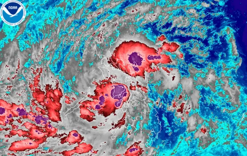
MANILA, Philippines – Tropical Depression Verbena made its third landfall in Talisay City, Cebu, at 2:40 am on Tuesday, November 25, then its fourth landfall in Vallehermoso, Negros Oriental, at 5:50 am.
Its first landfall had been in Bayabas, Surigao del Sur, at 1:30 pm on Monday, November 24, while its second landfall was in Jagna, Bohol, at 11:10 pm on the same day.
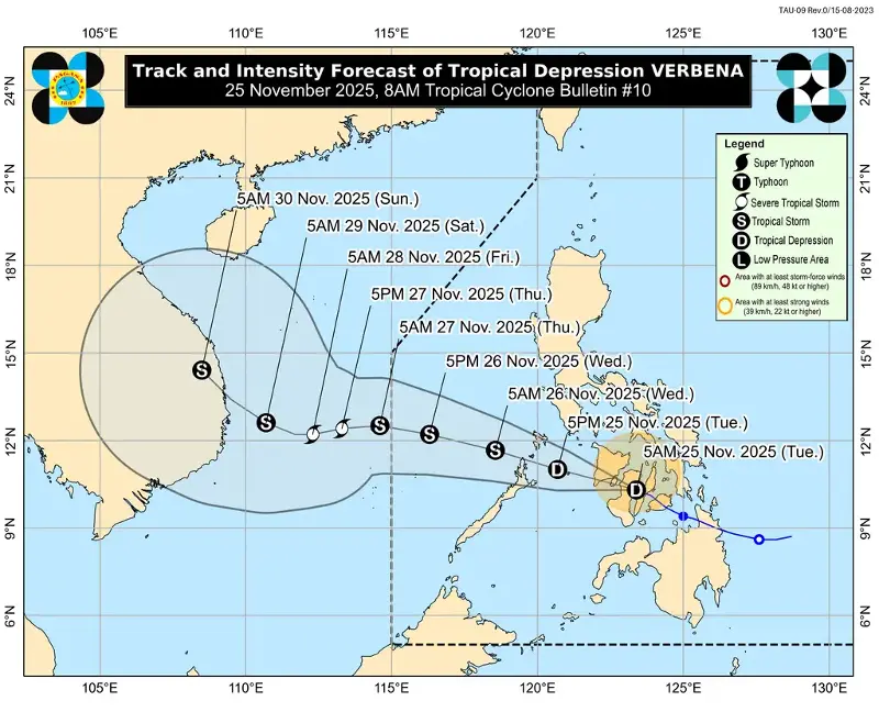
By 7 am on Tuesday, Verbena was already in the vicinity of Canlaon City, Negros Oriental, moving west northwest at 20 kilometers per hour (km/h).
The tropical depression still has maximum sustained winds of 55 km/h and gustiness of up to 90 km/h.
The Philippine Atmospheric, Geophysical, and Astronomical Services Administration (PAGASA) expects Verbena to keep moving west northwest across the Visayas and the northern portion of Palawan on Tuesday, before emerging over the West Philippine Sea by Wednesday morning, November 26.
PAGASA reiterated that Verbena is likely to remain a tropical depression while crossing the Visayas, but it may intensify into a tropical storm “before reaching northern Palawan or once over the West Philippine Sea.” It could peak as a severe tropical storm in the middle of the West Philippine Sea, north of Kalayaan Islands.
The worst rainfall from Verbena is generally shifting to the western side of the country, given the location and movement of the tropical depression. Affected areas must stay on alert for floods and landslides.
Tuesday, November 25
- Heavy to intense rain (100-200 millimeters): Palawan, Antique, Aklan, Capiz, Iloilo, Guimaras, Cebu, Bohol, Negros Occidental, Negros Oriental, Siquijor, Occidental Mindoro, Oriental Mindoro, Romblon
- Moderate to heavy rain (50-100 mm): Biliran, Eastern Samar, Northern Samar, Samar, Southern Leyte, Leyte, Marinduque, Catanduanes, Masbate, Albay, Sorsogon, Camarines Norte, Camarines Sur, Misamis Oriental, Misamis Occidental, Camiguin
Wednesday, November 26
- Heavy to intense rain (100-200 mm): Palawan, Oriental Mindoro, Occidental Mindoro
- Moderate to heavy rain (50-100 mm): Batangas, Marinduque, Albay, Sorsogon, Masbate, Catanduanes, Camarines Norte, Camarines Sur, Romblon, Capiz, Aklan, Antique, Iloilo
On Tuesday, other areas in Mindanao not listed above will also have scattered rain and thunderstorms due to Verbena.
Meanwhile, as the tropical depression continues to bring strong winds, here are the areas where Signal No. 1 remains in effect as of 8 am on Tuesday:
- Occidental Mindoro
- Oriental Mindoro
- Romblon
- northern and central parts of Palawan (Araceli, Taytay, El Nido, Dumaran, Roxas, San Vicente, Puerto Princesa City) including Calamian, Cuyo, and Cagayancillo Islands
- mainland Masbate (Balud, Mandaon, Milagros, Cawayan, Placer, Pio V. Corpuz, Esperanza, Uson, Dimasalang, Masbate City, Mobo, Palanas, Aroroy, Cataingan, Baleno)
- Antique
- Aklan
- Capiz
- Iloilo
- Guimaras
- Negros Occidental
- Negros Oriental
- Siquijor
- Cebu
- Bohol
- Samar
- Eastern Samar
- Biliran
- Leyte
- Southern Leyte
- Dinagat Islands
- Surigao del Norte
- northern part of Surigao del Sur (Carrascal, Cantilan, Madrid, Carmen, Lanuza, Cortes, San Miguel, Tandag City, Tago)
- Agusan del Norte
- northeastern part of Agusan del Sur (Sibagat)
- Camiguin
- Misamis Oriental
- northern part of Misamis Occidental (Sapang Dalaga, Calamba, Baliangao, Plaridel, Lopez Jaena, Oroquieta City, Aloran, Panaon, Jimenez, Concepcion)
- northern part of Zamboanga del Norte (Jose Dalman, Manukan, President Manuel A. Roxas, Katipunan, Dipolog City, Polanco, Piñan, Dapitan City, La Libertad, Sibutad, Rizal, Mutia)
The surge of the northeast monsoon or amihan and Verbena are also causing gusty conditions in areas not under tropical cyclone wind signals here:
Tuesday, November 25
- Luzon, Visayas, Dinagat Islands, Surigao del Norte, Agusan del Norte, Surigao del Sur, Davao Oriental, Misamis Oriental, Lanao del Norte, Misamis Occidental, Zamboanga del Norte
Wednesday, November 26
- Luzon, Western Visayas, Zamboanga Peninsula, Northern Samar, Eastern Samar, Dinagat Islands
Thursday, November 27
- Batanes, Cagayan including Babuyan Islands, Ilocos Norte, Mimaropa, Bataan, Cavite, Batangas, Western Visayas
Travel remains dangerous in seaboards affected by Verbena and the northeast monsoon on Tuesday.
Up to very rough seas (travel is risky for all vessels)
- Seaboards of Batanes, Cagayan, and Ilocos Region – waves up to 5.5 meters high
Up to rough seas (small vessels should not venture out to sea)
- Seaboards of Isabela, Aurora, northern mainland Quezon, Camarines Norte, and Kalayaan Islands; northern seaboard of Camarines Sur; eastern seaboards of Albay, Sorsogon, Eastern Samar, and Dinagat Islands; northern and eastern seaboards of Polillo Islands, Catanduanes, Northern Samar, and Siargao-Bucas Grande Islands – waves up to 4 meters high
- Seaboards of Zambales, Antique, and northern Palawan including Calamian and Cuyo Islands; southern seaboards of Occidental Mindoro and Oriental Mindoro – waves up to 3.5 meters high
- Seaboards of Lubang Island and Surigao del Sur; eastern seaboards of the rest of Quezon, Camarines Sur, and Davao Oriental; western seaboard of Occidental Mindoro; remaining seaboard of Catanduanes – waves up to 3 meters high
Up to moderate to rough seas (small vessels should take precautionary measures or avoid sailing, if possible)
- Seaboards of Romblon, Marinduque, Negros Occidental, Bantayan Islands, Cagayancillo Islands, and Davao Occidental; western seaboards of Bataan, Cavite, and the rest of Palawan; remaining seaboards of Quezon, Bicol, Western Visayas, Eastern Samar, Dinagat Islands, and Siargao-Bucas Grande Islands – waves up to 2.5 meters high
- Seaboards of Northern Mindanao and Zamboanga del Norte; western seaboards of Basilan, Sulu, and Tawi-Tawi; remaining seaboards of Batangas, Mimaropa, Visayas, and Caraga – waves up to 2 meters high
Verbena is the Philippines’ 22nd tropical cyclone for 2025, and the third for November, after Typhoon Tino (Kalmaegi) and Super Typhoon Uwan (Fung-wong).
It could leave the Philippine Area of Responsibility on Thursday morning, November 27.
Another source of rain is the shear line, or the point where cold air from the northeast monsoon converges with the easterlies or warm winds from the Pacific Ocean.
The shear line is affecting Metro Manila, the Cordillera Administrative Region, Central Luzon, Calabarzon, Cagayan, Isabela, Quirino, and Nueva Vizcaya on Tuesday.
PAGASA’s latest three-day outlook, released at 5 am on Tuesday, shows the provinces likely to be most affected by the shear line:
Tuesday, November 25
- Heavy to intense rain (100-200 mm): Quezon
- Moderate to heavy rain (50-100 mm): Cagayan, Isabela, Aurora, Batangas, Rizal, Laguna
Wednesday, November 26
- Heavy to intense rain (100-200 mm): Cagayan, Isabela, Aurora, Apayao
- Moderate to heavy rain (50-100 mm): Quirino, Nueva Vizcaya, Kalinga, Mountain Province, Ifugao, Nueva Ecija, Bulacan, Metro Manila, Quezon, Rizal, Laguna, Cavite
Thursday, November 27
- Moderate to heavy rain (50-100 mm): Cagayan, Isabela, Aurora, Apayao
Floods and landslides are possible, too. – Rappler.com