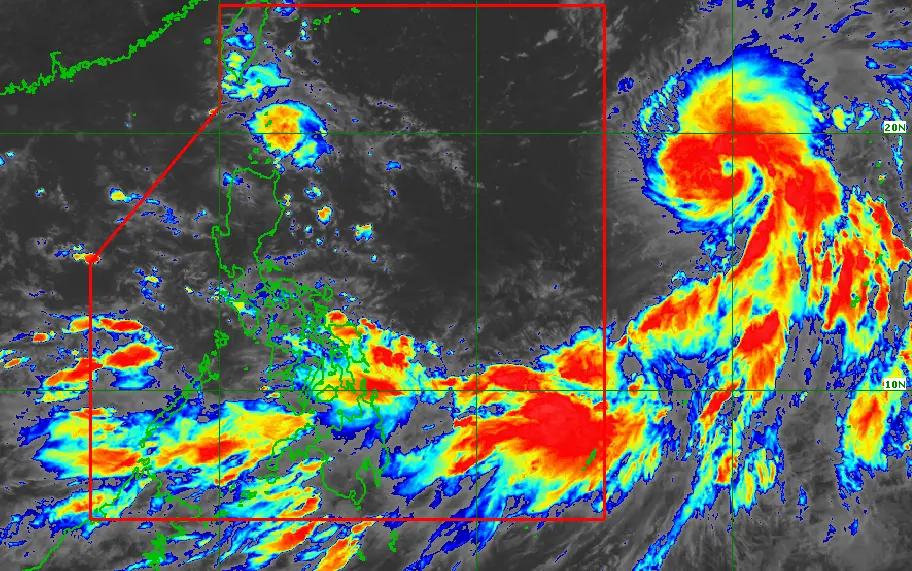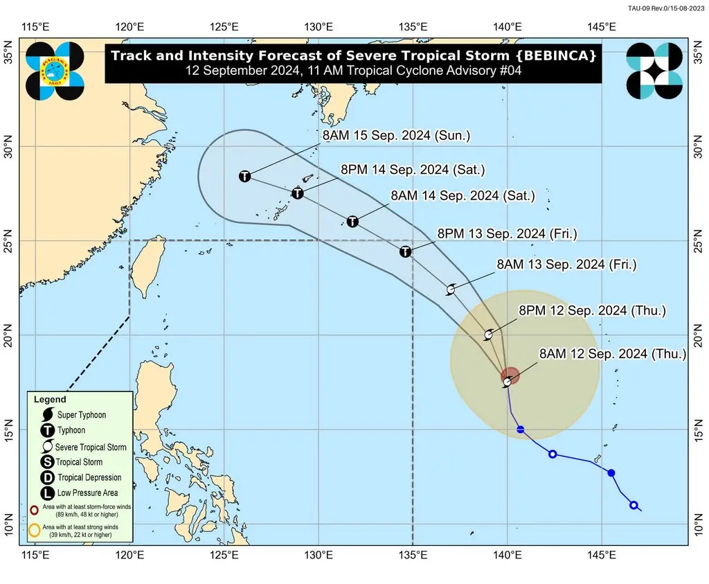
MANILA, Philippines – Severe Tropical Storm Bebinca, still located outside the Philippine Area of Responsibility (PAR), maintained its strength while enhancing the southwest monsoon or habagat on Thursday morning, September 12.
Bebinca was last spotted 1,975 kilometers east of Central Luzon or 1,930 kilometers east of Northern Luzon — over the Philippine Sea but outside PAR.
The severe tropical storm is moving north at a relatively fast 30 kilometers per hour (km/h).
Bebinca continues to have maximum sustained winds of 95 km/h and gustiness of up to 115 km/h, but it may strengthen into a typhoon by Friday evening, September 13.
The Philippine Atmospheric, Geophysical, and Astronomical Services Administration (PAGASA) still expects Bebinca to enter PAR on Friday afternoon or evening. When it enters, it will be given the local name Ferdie.
Bebinca or the potential Ferdie is also projected to exit PAR in a matter of hours — possibly late Friday evening or Saturday morning, September 14 — since it will only pass over waters near the PAR northeastern boundary.

While Bebinca will remain far from Philippine landmass, it is enhancing the southwest monsoon, which is causing rain in parts of the country.
In a separate advisory at 11 am on Thursday, PAGASA said the following areas are affected by the enhanced southwest monsoon:
Thursday noon, September 12, to Friday noon, September 13
- Moderate to heavy rain (50-100 millimeters): Masbate, Eastern Visayas, Surigao del Norte, Dinagat Islands, Palawan, Antique, Negros Occidental, Negros Oriental, Zamboanga del Norte, Sultan Kudarat, Sarangani, South Cotabato
Friday noon, September 13, to Saturday noon, September 14
- Heavy to intense rain (100-200 mm): Occidental Mindoro, Palawan, Antique, Negros Occidental
- Moderate to heavy rain (50-100 mm): Cavite, Batangas, rest of Mimaropa, Masbate, Sorsogon, rest of Visayas, Zamboanga Peninsula, Misamis Occidental, Lanao del Norte, Lanao del Sur
Saturday noon, September 14, to Sunday noon, September 15
- Heavy to intense rain (100-200 mm): Occidental Mindoro, Palawan, Antique
- Moderate to heavy rain (50-100 mm): Cavite, Batangas, rest of Mimaropa, Masbate, Sorsogon, rest of Western Visayas, Negros Island Region
Floods and landslides are possible.
ALSO ON RAPPLER
- Making sense of the Alice Guo enterprise
- Poe: Is Bangko Sentral at fault for allegedly subcontracting national ID production?
- LIVE UPDATES: Pope Francis tours Indonesia, Papua New Guinea, Timor-Leste, Singapore
- UAAP champ La Salle rides 20-6 opening quarter, blasts Adamson for second win
- Rebuilding empire? UST snaps 9-year, 17-game skid in late pullaway vs Ateneo
For the next 24 hours, the enhanced southwest monsoon will also cause moderate to rough seas in the eastern seaboard of Mindanao (waves 1 to 3.5 meters high); western seaboard of Palawan including Kalayaan Islands and western seaboard of the Visayas (waves 1 to 3 meters high); and eastern seaboard of Palawan, western seaboard of Mindanao, and southern and eastern seaboards of the Visayas (waves 1 to 2.5 meters high). Small vessels should not venture out to sea.
PAGASA added that up to moderate seas are expected in the southern seaboard of Mindanao (waves up to 2 meters high). The weather bureau advised small vessels to take precautionary measures or avoid sailing, if possible. – Rappler.com